Friday, August 18, 2017

August 18, 2017 Sky Surprise

I missed out on storm chasing this year for a number of financial and personal reasons, but I did get a nice treat this evening courtesy of a decaying mesoscale convective system (MCS).  I left work around 3:30PM to make it home in time to get my camera ready but I actually didn't end up using it. All of the photos below were taken with my cell phone.  As the squall line made its way over the Philadelphia suburbs, it showed promise of displaying a nice shelf cloud.  Unfortunately, by the time it made its way overhead, it had surged a bit too far south to see anything "great" at my location.

After Shana and I ran some errands, we stepped outside of the store we were at and we witnessed some Central Plains quality mammatus clouds.  I just about got us hit by cars in the parking lot as I drove around to find a somewhat open place for me to snap some photos.  I raced home afterwards and realized that the sky/sunset was fantastic too!  So, I jumped out of my car and snapped some more shots of the evening sky.  I haven't edited or tweaked these photos at all besides putting my name on them.  Enjoy.


Wednesday, June 22, 2016

June 22, 2016 Tampico-Deer Grove, IL supercell

Over the last few days there has been much hype surrounding severe weather today.  There was much uncertainty regarding the location storms would initiate, as well as the dominant storm mode.  I knew it would be a late decision on whether to chase or not due to the timing of early morning convection and how far north the warm front would make it.  Around 3PM I decided to start hedging west in hopes that I could be close to where the storms would develop.  However, from about 3-5PM I kept shifting west and slightly south as it seemed to be the most pristine environment for supercells.  Around 6PM I was south of Dixon, IL and noticed the rapid development of a supercell just west of me.  So, I dropped south and headed west toward Tampico-Deer Grove, IL.  Upon arriving there, I witnessed a really beautiful supercell starting to transition to a high precipitation variety.  I played around in the bear's cage for awhile and had some fun.  I let the storm roll by as it was supposedly producing a tornado (I could not see any tornado because of the heavy rain) and headed home by threading the needle on two tornado warned storms.  Overall, it was a great celebration of earning my Ph.D. this past week.  For those few that read/look at my photos taken with a 10 year old DSLR, enjoy.


Tuesday, May 31, 2016

5/31/16 DeKalb, IL shelf cloud

Took a few minutes off from working on my dissertation to take some shots of the incoming shelf cloud.  Very cool.  Enjoy.


Saturday, April 9, 2016

Fairdale, IL EF4 tornado one year later

Today is the one year anniversary of the EF4 Fairdale, IL tornado that killed two and injured dozens. This time last year I was trying to process what had just happened and what I had seen on my chase. I witnessed an extremely powerful and photogenic wedge tornado dancing across the empty corn/soybean fields of Northern Illinois hoping it missed farm houses and communities like threading a needle. However, word soon got out that the community of Fairdale took a direct hit. Given how the tornado looked during my chase, I knew that there would be fatalities.  The day after the tornado in 2015, I was invited by the NWS to assist with the damage survey.  The damage I witnessed that day was extremely sobering, but the community members of Fairdale were extremely positive and ready to move on.  Today I was reminded of their resilience when I attended the Fairdale memorial dedication service. It was great to see the community bouncing back and looking forward to the future.

Below are two press releases that Tom Parisi (NIU Newsroom), Walker, and myself worked on over the past two weeks.  One is not directly related to Fairdale, but illustrates some key research findings than can be put into light with the Fairdale tornado event.  The second press release is a map that Walker and I created that groups videos, photos, and the tornadoes path.  It's an interactive story map that illustrates the event from many different view points.  I share these in hopes that you folks will enjoy the articles and map while thinking about your own tornado vulnerability. Do you have a plan? Do you know what to do when there is a tornado warning? What about your loved ones? Please, have a plan and take action. It's your life and your responsibility to protect it.


One last link I want to share with you all.  This video was taken by Mr. Clarence "Clem" Schultz, a veteran and someone who lost his wife in the Fairdale tornado event.  He is lucky and thankful to be alive.  I am sharing this video so we can all be reminded of the ugly and SCARY side of nature. 


================================================================================================================================================


Thursday, September 10, 2015

September 10, 2015 DeKalb, IL Gravity Wave/Undulatus Asperatus

This morning was interesting here in DeKalb.  Soon after I woke up this morning I realized I had to rush out the door to make it to Davis Hall in order to see the incoming gravity wave set off from storms to the north of town.  Following my record setting pace into Davis Hall, I ran up the steps to the roof and grabbed a few panorama shots as the undular bores made their way past DeKalb.  After a 20 minutes or so I decided to head back into my office since I had work to do.  About 2 hours later I received a text from Walker telling me to get back up to the roof (with a "but don't jump" quip through in for good measure) and take some more panoramas of the outflow from the next round of storms.  So, I ran back upstairs and snagged some nice undulatus asperatus bubbling by.  Overall, it was great to see some great sky "stuff" for once around here. (I will add radar animations later).

I highly recommend that everyone check out this timelapse (watch it until the end!) from the NIU Meteorology Program skycams.  This is the exact reason Walker decided to put up these webcams. When you speed things up, average, somewhat interesting things in the sky turn into amazing and dramatic scenes,  The atmosphere is a fluid, people!  Don't believe me?  Check this out.


Saturday, May 16, 2015

May 9th, 2015 Grinnell, KS Tornadoes

As the end of the spring semester at NIU concluded it became more evident that this weekend would yield some opportunities to chase out west.  It was a tough setup given the lack of an elevated mixed layer (EML) and overnight convection.  The lack of an EML allowed storms to initiate early in the day and prevent one storm to become dominate.  Plus, the overnight convection really squashed large swaths of potential chase targets until sunset or later.  Yet, prospects looked good enough to make the trip and gamble.  We left DeKalb Friday afternoon bound for Topeka, KS where we overnighted. The next day our target was Garden City, KS. However, as we soon realized, a large mesoscale convective system (MCS) was in our way. We made it to Garden City and slowly moseyed west toward better convergence and (relative...) moisture. Storms in extreme SW KS really couldn't get going and we had no shot at catching the tornado confirmed storm in Colorado. We waited on a few storms but they really looked "mushy" and struggled to do much of anything. So, we actually gave up on the day and headed toward Salina, KS where we were going to stay the night. As we were heading east towards Oakley, KS on highway 40 we notice that where was a boundary sinking down from the north.  There were some beautiful cumulus, in a favorable shear environment, ahead of us as we pushed through (see the attached link to Walker's blog post and video). We hoped that the boundary could interact with a storm and maybe spin up a quick tornado. Sure enough, as we reached Oakley, KS and I-70, a storm crossing the boundary became tornado warned and a tornado was confirmed with it. We headed east on I-70 toward Grinnell, KS where we waited at the offramp for it. The frustrating part is that we needed to get south but couldn't because the muddy, non-paved roads. Finally, as we sat there in forward flank region with rain/small hail, visibility improved and we confirmed tight rotation. Sure enough, it began to produce what was a fairly long-lived tornado. As darkness began to creep in, two areas of rotation were present and it produced multiple tornadoes from these different rotation mesocyclones. Although we saw what was 5-6 tornadoes (some brief), it was a frustrating day at times. Note: I did not get photos because I was driving, had wide-angle lens on, and it was low light.  So, I have taken some of Walker's photos and put them on my blog.  I encourage all of you to go to his blog for higher quality, more photos, and a different take on the event.  His blog post can be found here -->  HERE

Day two of our chase led us to extreme SE North Dakota/NW Iowa. Driving north out of Salina in the morning it was pretty apparent early on that it would be a long day given storms were firing by 10AM. In fact, there was a confirmed tornado near Mitchell, SD by late morning. We just raced north to get to a position where storms would have a chance to get organized. We arrived in far NW Iowa and everything just looked sloppy. It was not great. We waited around and saw some storms but by 5PM we decided to head back home as everything turned into a big mess. It just didn't look great.  As we were on our way to Des Moines, a storm about 75 miles away from us produced a tornado that was highly visible. This was frustrating because the environmental ingredients were not great and one would have to have been lucky to get the tornado. It was one of those things....

We decided to head all the way home on Saturday. That was probably a mistake because we were all more tired than expected. Fortunately, we made it home safely. All in all, it was a rough chase for me. I have a tendency to like chases where the storm motion is slow and I can take my time to relax. Don't get me wrong, I like seeing storms and chasing regardless, but 2,200 miles in 3 days wasn't a great way for me to relax.  I guess this is what I get for chasing an early May dynamic low instead of early/mid-June bowling ball lows.  Maybe I'll get another chance in June to see my favorite slow moving supercells, spaceships and barber poles. I have a lot of dissertation work to knock out within the next few weeks so maybe mother nature will hold off on the storms. But watch, here come the most visually stunning storms of the year. Mark my words. One day this won't be an issue. I'll chase whenever I want.

ALL PHOTOS AND VIDEOS HEREIN ARE COPYRIGHTED BY WALKER ASHLEY (chubasco.niu.edu)


Saturday, April 11, 2015

April 9, 2015 Rochelle/Fairdale, IL EF4 Tornado

After another long winter here in DeKalb where we broke some of those records you never want to touch (e.g., cold temperatures and a lot of snow!), we have finally seen the warmth return to the area for the most part.  However, days like yesterday begin to put things in perspective.  They are a sober reminder of how beautiful, yet ugly, nature can be.  Throughout this week local (NWS Chicago) and national (SPC) had been hinting at the potential for severe thunderstorms in Northern Illinois on Thursday (4/9).  As Thursday neared, I continually poo-pooed the chances of severe weather because of lackluster supercell and tornado ingredients.  For the most part I was correct, and I wish I would have been 100% correct.

Throughout Thursday, whist preparing for my Ph.D. candidacy exam, I continually monitored visible satellite, surface observations, and radar from my office at NIU in DeKalb until about 4:30PM.  I decided to head home around 4:45PM to keep a closer eye on radar in case I wanted to head out and see some convection.  I noticed that the storm north of Davenport, IA was probably going to be the storm of the day because it was a heavy precipitation beast of a supercell.  But, reports coming out on that storm were lackluster and chasers were having a hard time because of the Mississippi River pinning them in Iowa.  I was still a bit down on the whole setup because the veered surface winds (usual here in No. IL resulting in mixed storm mode and linear segments).  However, an isolated storm was able to form east of the larger, more dominant storm near the Quad Cities in Iowa.  This isolated storm was supercellular in nature as it formed along the warm front and looked to be headed for Rockford at the time (
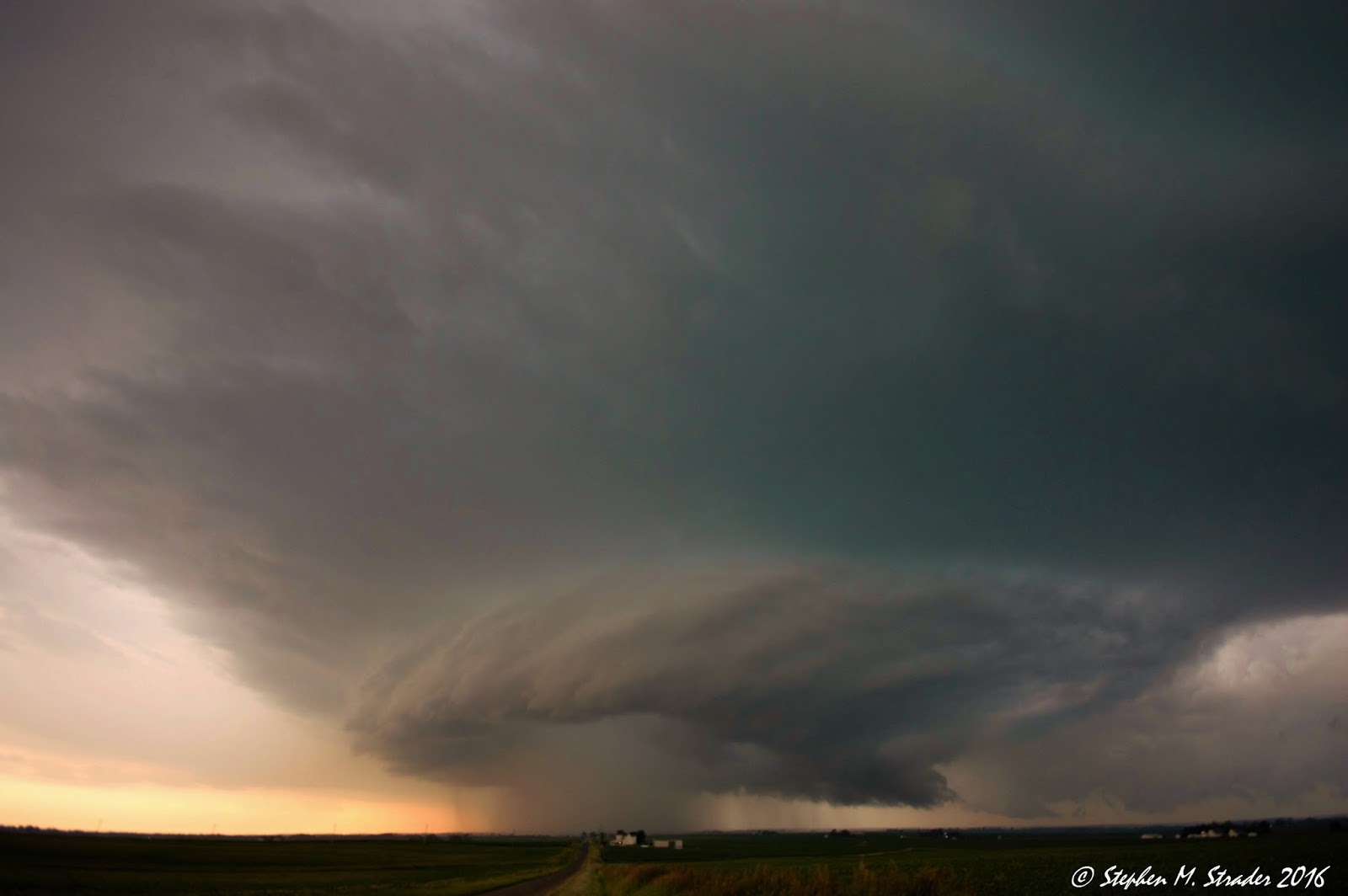
Radar loop). It ultimately did produce a tornado too.  I knew with storm translational speeds being approximately 50mph, I had no chance of catching up to it.  However, I did notice that a new storm was beginning to develop in its wake or outflow. I was hoping to head off this storm in western DeKalb county to see some "pretty" convection.  As I began to move out, I noticed that the storm started taking on some supercellular characteristics.  It illustrated really impressive gate-to-gate shear and a classic supercell radar signature.  So, I headed west towards the storm hoping I could see something of interest.  As I got closer and closer to the storm things got more and more interesting.  I finally got a glimpse of its base about three miles north of the local community college here in DeKalb Co. What I noticed next was something surprising as well as terrifying.  To my disbelief, there was a large wedge tornado on the ground and it was scouring the landscape!  I jumped out of the the truck and began taking photos (wide-angle so the tornado was closer than it appears in the photos) of the beast while it was churning up the ground.  The structure was great and I was thoroughly shocked at what I was seeing with my own eyes.  I had to gather myself and get a plan, quick. The only option was to head north and try to keep up with the fast-moving storm.

As I started moving alongside of it, I noticed that it was steady-state (i.e., it was not varying at all).  It looked like it could go forever.  Some tornadoes just have a "special" look to them where they could go hundreds of miles.  This one was one of those types from my vantage point.  Unfortunately, it looked like it was creating damage as it was traversing the landscape.  Early on I knew that this would be a killer tornado....  I would have bet on it.  It looked like a violent and destructive monster. I could only hope that it would miss all of the farmsteads and communities peppered throughout DeKalb Co.  Overall, I followed the tornado north through DeKalb Co. up to just west of Kirkland for about 30 minutes.  It did not lift once and kept thrashing the ground like a spinning bolt.  Little did I know, as I watched it cross right in front of me on Esmond Rd. it was hitting Fairdale, IL.  Sadly, this resulted in two fatalities.  Given the storm speed, I was unable to keep up with it safely, so I decided to wave it goodbye.  At this point my nerves were shot from chasing a fast moving wedge tornado by myself (radar, phone, visual, dirt roads, etc. can be a lot to deal with while driving!).  I headed home.

I noticed that as I pulled off headed east on hwy 72, there were blue and red lights about a mile to my west.  I thought that it might just be a barn that was hit.  Unfortunately, it was Fairdale, IL as I found out the next day.  Later on that night, still wired, I was wondering how that type of storm was produced in this type of environment.  I am confident after speaking with speaking with other meteorologists, that a storm that initially developed in the Morrison and Dixon area left behind a boundary that "fed" the tornadic storm I witnessed.  In fact, this storm may have helped reinforce the warm front back southward at the surface. This could have caused the winds to back locally in Rochelle, leading to enhanced storm relative inflow that ultimately yielded in a long-lived, long-tracked, and violent tornado.  A more complete and better postmortem analysis will hopefully reveal mine and other's suspicions.

Another opportunity was presented my way late Thursday night when I was placed on one of the NWS Chicago damage survey teams.  This meant that I was able to tag-along, help out, and provide another set of eyes for the damage survey to be conducted that next day.  As someone who had seen significant tornado damage first hand (2005 Evansville, IN EF3 tornado), I knew it would be a difficult thing to witness.  However, I thought it would be an valuable experience and something from which I could benefit.  And perhaps, my previous research on tornado damage intensity estimation techniques could provide some useful insight.

The team I was on included Gino Izzi (NWS Chicago WFO/NIU graduate), Walker Ashley (NIU professor/my adviser), and Victor Gensini (COD professor/former NIU grad. student).  We were tasked with surveying the portion of the path from Rochelle, IL up to and including Fairdale, IL.  This portion of the path was believed to be the most heavily hit as well.  Overall, the tornado damage path began confirming what myself and other chasers witnessed.  The tornado started out as a needle and gradually became a monster wedge.  We focused a lot of our efforts on the community of Fairdale as it seemed to be the hardest hit or at least the most heavily impacted.  Once we arrived in Fairdale we came upon utter devastation.  Most of the community was a pile of rubble.  Beginning our survey in the interior of Fairdale, we noticed that many of the homes that were impacted were older.  This potentially means that they may not be as structurally sound as they could have been.  Suspicions were confirmed when we noticed the homes that were the most heavily damaged were not bolted or fastened to their foundations.  Many were simple cinder block based homes with the majority of the structure placed on top of the blocks with a few nails here and there.  Unfortunately, this meant that we couldn't rate the tornado violent at this point because the damage indicators simply did not support greater wind speeds.  As we walked around we did notice that many cars were lofted and rolled within the community which led to the potential for higher wind speeds.

As we moved back to the southwest portion of the path we knew there were a few structures that we wanted to survey near the intersection of route 251 and hwy 64.  We arrived on these structures and immediately knew that this was the worst damage we had seen thus far.  We noted that the homes in this area were newer/better built.  They were bolted down to the foundation but swept fairly clean. Of note, there was a smart car and a dumpster that had been lofted, not rolled, 200 yards from its driveway.  Based on our survey of this area and other teams' findings, it was decided that it was violent tornado damage at it's maximum intensity.  This means winds greater than 166mph.  It puts it in the 1-2% of all tornadoes with a recurrence interval of about 1 every 6 years in No. IL from 1950 to 2014 .

Overall, everyone we came across was upbeat and positive.  People were bouncing back and praising the advanced warnings from the NWS.  I was amazed at the excellent job done with the tornado warnings by the NWS Chicago WFO as well.  I was even more amazed with the resilience of the people impacted by this monster.  Sometimes events like these put things in perspective......

For more and official information on the event please go to the NWS Chicago WFO webpage HERE

Note:  All photos herein are copyrighted by myself and the National Weather Service.  Please email if interested in their use. 


As the tornado was approaching I-39


Just as the tornado was hitting Fairdale, IL. 


Homes at the corner of 251 and hwy 64 

Fairdale, IL

 West of Rochelle, IL


 Fairdale, IL


No bolts.  Just nails.  


Corner of 251 and hwy 64.  Note the bolting down to the foundation. 


Vehicle that had be displaced 50 yards or so.

One of the most impressive displays.  Smart Car was lofted 200 yards from the home.  


Oh, and a steel dumpster was too.  


Steel reinforced solid concrete silo that had not only been tumbled off its foundation but also twisted.